Creationist Geology, part 2

In Part 1 of this blog we found that the creationist geology must have the following structure:

Figure 1 – Creationist Geology with Pre- and Post-Diluvian Layers

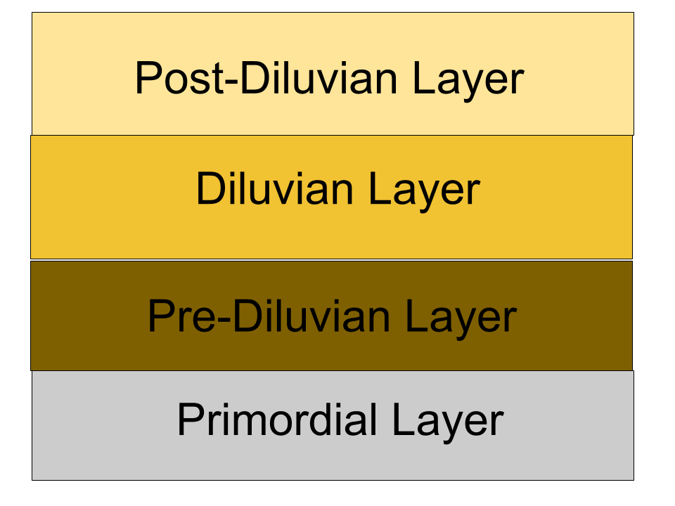
The diagram seems to indicate that the Pre-Diluvian, Diluvian, and Post-Diluvian layers are all about the same thickness. But is that what the bible says?

The bible has its own internal chronology, which I have documented in this blog entry: https://david-seldon-moore.blog/2019-09-14-biblical-chronology-part-2

Based on that chronology we can assign some well known dates to some of the boundaries of the diagram, as shown below:

Creationist geology with some well known dates

The only boundary to which we cannot immediately assign a date is that between the Pre-Diluvian and the Diluvian layers. To know how thick the Pre-Diluvian layer must be we would have to know how long it takes sedimentary rock to solidify, according to the bible.

We can answer that question by considering this passage:

The sons of Ham: Cush, Egypt, Put, and Canaan.

Genesis 10:6, Revised Standard Version

Ham was one of the sons of Noah. So this passage means that according to the bible the nation of Egypt didn’t exist until after the flood.

Mainstream archaeology says that the unification of Upper and Lower Egypt happened sometime between 3100 and 3000 BCE. That’s at least 500 years before the time of the flood.

Of course creationists don’t accept any of the claims of modern archaeology– they regard the findings of archaeology as every bit as suspect as those of modern physics. So let us now investigate the Step Pyramid, constructed by the Pharaoh Djoser. According to mainstream archaeology this building was constructed at around 2650 BCE, though of course creationists do not accept that date as it predates the flood, according to the biblical timeline.

Let us for the moment entertain the possibility that both Egypt and this building were created after the flood and see if that leads to any complications.

The key fact about the Step Pyramid that makes it so important to this discussion is that it is made of stone. That means that by the time this building was built the sedimentary materials deposited by the flood must have solidified to become rock.

So according to the bible Ham, the son of Noah, had a son Egypt, who would have had to travel from the mountains of Ararat (probably in modern Turkey) to the Nile river valley. Then his descendants would have had to populate the valley and effect the unification of Upper and Lower Egypt, and after a period of time that was at least 350 years, according to mainstream archaeology, the Step Pyramid would have been built. Here’s the sequence:

  • Ham’s son Egypt is born
  • Egypt and his family migrate to the Nile river valley
  • The entire Nile valley is populated with about 100,000 people
  • Upper and Lower Egypt are unified to form the nation of Egypt
  • Pharaohs of the Old Kingdom make Egypt the greatest nation on earth over a period of at least 350 years
  • Pharaoh Djoser commissions the construction of the Step Pyramid, using stones quarried nearby

We can’t provide an estimate for the times of the first two events in the above list. There is nothing in the bible that specifically dates either of these events. The third event– the population of the Nile river valley– would have taken about 500 years. And according to mainstream archaeology the sixth event would have happened about 350 years after the second.

What we need is some way to correlate the above sequence of events to the timeline of the bible. Conveniently there is this passage in the bible:

In the fifth year of King Rehoboam Shishak king of Egypt came up against Jerusalem; he took away the treasures of the house of the LORD and the treasures of the king’s house; he took away everything.

I Kings 14:25, Revised Standard Version

The date of this invasion is established by external sources as 925 BCE. So now we have the following approximate chronology for the events leading up to the invasion of the Levant:

  • The flood ends in 2460 BCE
  • Ham’s son Egypt is born
  • Egypt and his family migrate to the Nile river valley
  • The entire Nile valley is populated with about 100,000 people over a 500 year period
  • Upper and Lower Egypt are unified to form the nation of Egypt
  • Pharaohs of the Old Kingdom make Egypt the greatest nation on earth over a period of at least 350 years
  • Pharaoh Djoser commissions the construction of the Step Pyramid, using stones quarried nearby
  • A great many pharaohs rule Egypt over a period of 1725 years
  • The pharaoh Shishak / Shishonq I invades the Levant in 925 BCE

So there is a total of 1535 years between the end of the flood and the invasion of the Levant in 925 BCE. But the events listed above would have taken a minimum of 2575 years, according to mainstream archaeology. The only way that Creationists can make this work is by scrunching 2575 years of events into a 1530 year period. Doing so will of necessity move the time of the construction of the Step Pyramid closer to the time of the unification of Upper and Lower Egypt. Mainstream archaeology says that took about 350 years. Let’s say that Creationists scrunch it down to 250 years. Well, that gives us the date we need. 500 years to get Egypt son of Ham from the mountains of Ararat to the Nile river valley and to populate it with about 100,000 people; and 250 years to prepare the way for the construction of the Step Pyramid. That’s a total of about 750 years– the minimum time it would take for sedimentary material to solidify and become rock, according to the bible. And now we can redraw the diagram to show the relative sizes of the layers of rock:

Completed Creationist Geology

The diagram is not to scale, but here are the relative sizes of the 3 non-primordial layers:

  • Pre-Diluvian Layer: 907 years; about 14.7% of the total
  • Diluvian Layer: 750 years; about 12.2% of the total
  • Post-Diluvian Layer: 4479 years; about 72.9% of the total

The upshot of this discussion is that the Diluvian layer is the only layer that could possibly be hydrologically sorted; yet it accounts for no more than 12.2% of the total fossil record. All of the rest of the fossil record– by far the majority– should be chronologically sorted. So hydrological sorting cannot possibly account for the sequencing of the fossils in the geological record, and creationist geology doesn’t even accord with the creationist interpretation of the biblical narrative.

Written 2019-06-10.

Copyright (c) 2019 David S. Moore. All rights reserved.

Creationist Geology, part 1


Young earth creationists claim that the entire universe was created in six days, and that those days were not “days in the eyes of God” but actual real 24 hour periods of time.

Modern geology says that the oldest rocks of earth are about 4.2 billion years of age, that the oldest rocks of our solar system are about 4.5 billion years of age, and that life has existed on this planet for at least 3.5 billion years.

Young earth creationists say that’s completely wrong.

So what do young earth creationists have to say about geology? How do they counter the vast wealth of geological knowledge that has been accumulated since the time in 1799 when William Smith produced the world’s first map of geological outcrops?

Chiefly, they deny that the many measurements of the ages of the rocks of earth are accurate. This propaganda campaign has lost every assault that creationists have brought against modern geology in courts of law across this land. But that has done little to dissuade the advocates of young earth creationism from continuing to claim that modern geology is somehow flawed, or biased, or based on unsound principles.

To amend for the deficiencies of mainstream geology young earth creationists have invented their own fantasy geology. It looks like this:

This image has an empty alt attribute; its file name is creationist-geology-1.png
Figure 1: Young Earth Creationist geology

This geology consists of two significant layers:

  • The Primordial layer, which was created by God at the time of the creation
  • The Diluvian layer, which contains the entire fossil record and was created by the flood

The rocks of the Primordial layer are presumed to be as old as the universe. In the young earth creationist view that would make the rocks of this layer about 6100 years old.

As mentioned above modern geology pegs the oldest rocks of earth at about 4.2 billion years old. That is about 70 MILLION percent longer than the 6100 years that creationists claim the universe is old. That’s an enormous percent of error.

Bear in mind that modern science is generally not satisfied with anything less than 5 sigma accuracy. That represents an accuracy of 99.97%. That level of accuracy is routinely obtained in physics. Science is the process by which humanity has learned how to build the products of modern technology– automobiles, refrigerators, computers, cell phones… The types of consumer products that all citizens of the modern world, including creationists, use and enjoy every day. And yet creationists expect us to believe that physics– which developed the tools for measuring the ages of rocks– is off by 70 MILLION percent.

The rocks of the Diluvian layer were supposedly created when the waters of the flood receded. According to this line of thinking, the waters of the flood rushed across the face of the earth and ripped up all loose dirt, clay, mud, gravel, sand, and topsoil. These materials were then dissolved in the water and held in suspension in a six mile deep stew. Then when the waters of the flood settled down the materials held in suspension settled out into nice neat layers. And when the waters of the flood finally receded those neat layers were perfectly preserved, as is seen in such layered cake formations as the Grand Canyon.

A key component of this fantasy geology concerns the ordering of the fossils in the fossil record. Everyone, even creationists, agree that the fossil record is highly ordered. Mainstream geology asserts that the layers of the fossil record were deposited chronologically, with the oldest layers at the bottom and the layers getting progressively younger as you ascend the geological column.

But creationists argue that because the entire fossil record was laid down all at once by the draining of the waters of the flood the fossils in the fossil record aren’t ordered chronologically. Instead, creationists claim, the fossils were sorted by the waters of the flood. So the ordering of fossils in the fossil record is based on the hydrological properties of the bodies of the animals and plants killed by the waters of the flood. This is what creationists call hydrological sorting.

There is no proof that this notion of hydrological sorting could explain the observed ordering of fossils. Consider bivalves. Fossils of these animals can be found throughout the fossil record. Bivalves can be found in the Ordovician strata, which mainstream geology dates to 488 to 443 million years ago; and many bivalves from that era closely resemble modern bivalves. So their hydrological properties should be strongly similar. Why would one group of bivalve fossils be found at a lower level than another if hydrological sorting were the only physical principle in operation?

Creationism isn’t a science, and although there are a million scientific objections to the creationist fantasy geology, none of them would have much impact on the thinking of a creationist who can find reason to believe that modern science is off by 70 MILLION percent. So rather than attempt to provide the scientific evidence that creationists will never accept anyway I will show that creationist geology doesn’t even comport with their own narrative.

According to the bible there were people and animals and plants that lived and died prior to the flood. Question: what would have happened to their bodies? Answer: Over time their bodies would have been covered with sediment. That sediment would have gotten compacted and compressed and would have turned to rock. And the bodies entombed therein would have been converted to fossils. That means there should be another layer of fossils below the diluvian layer that contains the fossils of the people and animals and plants that lived and died before the flood, as shown in the following diagram.

This image has an empty alt attribute; its file name is creationist-geology-2.png
Figure 2: Creationist Geology with Pre-Diluvian Layer

Most importantly, the fossils of this layer would have been laid down chronologically and would therefore not be hydrologically sorted. That means that the boundary between the Pre-Diluvian layer and the Diluvian should be unmistakable and very easy to identify.

Furthermore, according to the bible there were people and animals and plants that lived and died after the flood. Question: What would have happened to their bodies? Answer: Over time their bodies would have been covered by sediment. That sediment would have gotten compacted and compressed and would have been turned into rock. And the bodies entombed therein would have been converted to fossils. That means there should be another layer of fossils above the Diluvian layer that contains the fossils of the people and animals and plants that lived and died after the flood, as shown in the following diagram.

This image has an empty alt attribute; its file name is creationist-geology-3.png
Figure 3 – Creationist Geology with Pre- and Post-Diluvian Layers

This layer too would have been deposited chronologically, and therefore the boundary between this layer and that of the Diluvian layer should be clear and easy to identify.

So has this pattern ever been observed at any location anywhere in the world? No, decidedly not. And people have looked. Here are 25 locations where geologists have observed all 12 of the periods of the Phanerozoic in order:

  • The Ghadames Basin in Libya
  • The Beni Mellal Basin in Morrocco
  • The Tunisian Basin in Tunisia
  • The Oman Interior Basin in Oman
  • The Western Desert Basin in Egypt
  • The Adana Basin in Turkey
  • The Iskenderun Basin in Turkey
  • The Moesian Platform in Bulgaria
  • The Carpathian Basin in Poland
  • The Baltic Basin in the USSR
  • The Yeniseiy-Khatanga Basin in the USSR
  • The Farah Basin in Afghanistan
  • The Helmand Basin in Afghanistan
  • The Yazd-Kerman-Tabas Basin in Iran
  • The Manhai-Subei Basin in China
  • The Jiuxi Basin China
  • The Tung t’in – Yuan Shui Basin China
  • The Tarim Basin China
  • The Szechwan Basin China
  • The Yukon-Porcupine Province Alaska
  • The Williston Basin in North Dakota
  • The Tampico Embayment Mexico
  • The Bogata Basin Colombia
  • The Bonaparte Basin, Australia
  • The Beaufort Sea Basin/McKenzie River Delta

(For more details see: http://www.talkorigins.org/faqs/geocolumn/)

In none of the above formations has the creationist pattern ever been observed. But if creationists are correct their pattern should be observable in every geological formation around the globe.

In creating the previous diagram I have cheated somewhat. I’ve made it appear that the three layers– the Pre-Diluvian, Diluvian, and Post-Diluvian– are all of about the same thickness. But is that what the bible tells us? We will explore this question further in Part 2 of this blog.


Written 2019-06-09.

Copyright (c) 2019 David S. Moore. All rights reserved.

Was The Grand Canyon Created by the Flood?

Some Creationists claim that the Grand Canyon was created by the biblical flood. Is that true?

The waters of the flood

Before we can figure out what the waters of the flood may have sculpted we should first try to understand where the waters came from. The story of the flood (as reported in the bible) says the following:

In the six hundredth year of Noah’s life, in the second month, on the seventeenth day of the month, on that day all the fountains of the great deep burst forth, and the windows of the heavens were opened. And rain fell upon the earth forty days and forty nights.

Genesis 7:11-12, RSV

So we now know that some portion of the waters that covered the earth came from the skies in the form of rain, and the rest burbled up from the depths. The bible gives us a very specific measure of the total amount of water that covered the earth:

And the waters prevailed so mightily upon the earth that all the high mountains under the whole heaven were covered; the waters prevailed above the mountains, covering them fifteen cubits deep.

Genesis 7:19-20, RSV

That works out to a depth of about 6 miles across the entire planet. Let’s suppose that the waters which poured down from the skies came directly from the atmosphere, and that those waters were returned to the atmosphere when the flood waters receded.

Question: If we were to extract all of the water vapor currently held in suspension in the atmosphere and dump it all over the surface of the earth, how deep would the resulting ocean be?

Answer: About 1.5 inches. That’s a far cry from 6 miles. (https://www.livescience.com/how-much-water-earth-atmosphere)

The atmosphere just doesn’t have the capacity to store even one tenth of the six mile depth of water that covered the planet. The only way to increase the atmosphere’s holding capacity would be to greatly increase the temperature of the atmosphere– to several hundred degrees. Furthermore, that much water in the atmosphere would massively increase its density– to about the same pressure that would be found at the bottom of a 3 mile deep ocean. That’s about three tons per square inch! That’s simply not survivable.

At this point we don’t even know where the water that rained down on the planet for 40 days and 40 nights came from. So let’s assume that half of the 6 mile depth of water was due to the rains that fell from the sky, acknowledging that we still don’t know how the atmosphere could have held that much water, and that the rest of the water surged up from below the surface of the earth. We will further assume that the water that fell from the skies was returned to the atmosphere (by an unknown mechanism), and that the water that burbled up from the depths returned to the depths. And we shall conjecture that the waters that returned to the depths carved the Grand Canyon as they receded.

The fossil record

Creationists claim that the entire fossil record was created by the flood. They say that the waters of the flood rushed across the face of the earth and dissolved all of the loose dirt, clay, mud, gravel, and topsoil, along with the bodies of all of the people, animals, and plants that were killed by the flood. Then as the waters calmed, the materials held in suspension settled into neat layers arranged by “hydrological sorting,” a fancy phrase meaning “in order of natural buoyancy.” When the waters receded those nice neat layers were perfectly preserved, as seen in the walls of the Grand Canyon, and in many other such geological formations around the world.

The above narrative means that at the time the waters of the flood receded, the entire surface of the earth would have been covered in a thick layer of mud. As water rushed across the mud on its way to disappear into the depths, it wouldn’t have carved nice neat walls in the mud. When massive torrents of water rush across a landscape of mud, the mud just collapses. So the result would not have been the carving of a canyon with crisply defined walls– it would have been a massive undifferentiated pile of mud. And after the water had receded the mud would have leveled out to form a plain– which is literally the opposite of a canyon.

Another question: Why did the mud of Arizona get carved into a canyon, rather than, say, the mud of central Texas? Texas is pretty flat, and there aren’t many examples of canyons across vast stretches of the Lone Star State. But if the creationist narrative about the creation of the fossil record is true, then at the time that the waters of the flood receded, the mud of Texas should much the same composition of the mud of Arizona. There shouldn’t be any reason why a canyon would have been carved in Arizona but not in Texas.

Unless, of course, there was a drain somewhere in northern Arizona and the waters of the flood rushed toward that on their way back down to the depths. But when water rushes down a drain it creates an eddy– a whirlpool– and the Grand Canyon definitely does not look as though it was carved by a whirlpool.

A true flood geology

The simple fact is that the Grand Canyon isn’t a flood geology– it’s a river erosion geology. For an example of a true flood geology the place to look would be Eastern Washington State in a region known as the Channeled Scablands. As settlers traveled through this region they saw that the land consisted chiefly of exposed bedrock with little or no soil. They called the region a “scabland” because it was land that was unsuitable for farming.

The Channeled Scablands were formed by dozens, perhaps hundreds of floods that happened at the end of the last ice age, between 15,000 and 14,000 years ago. The waters of a glacial lake named Lake Missoula were held back by an ice dam that repeatedly broke over a course of many hundreds of years, releasing more water than is contained in Lake Ontario and Lake Erie combined. Those waters rushed across Northern Idaho and Eastern Washington, scouring the surface down to bedrock and pushing the accumulated soil, gravel, clay, and rocks to the south and west. These floods are known collectively as the “Lake Missoula Floods.” Some of these floods resulted in volumes of water that would have been ten times greater than the sum of all of the rivers of the world combined.

The region of the Channeled Scablands, which is 9 times the area of the Grand Canyon, is populated with a number of geological features that are characteristic of flood geologies, none of which are to be found in the Grand Canyon.

Coulees

The Channeled Scablands has more than 140 geological formations known as coulees. These are large gullies that were carved by water– in a region where there is presently no source of water. The Grand Coulee is more than 60 miles long. These very distinctive formations can be seen throughout the region. There is not a single coulee to be found in the Grand Canyon– because the Grand Canyon does have an obvious source of water: the Colorado River.

Kolkes

A kolke is a giant conical divot that has been carved by water out of bedrock. There are hundreds of kolkes across Eastern Washington. The colloquial term for them is “potholes.” Washington State even has a state park named “The Potholes State Park.” Kolkes were formed when water several hundred feet deep rushed across the land at 45 to 60 miles miles per hour. The rushing water created whirlpools that drilled into the bedrock, creating conical divots that later filled with rainwater to create small, isolated lakes.

Ripples

When water rushes across a landscape it can form ripples in the land. Beachcombers are familiar with this phenomenon– as can be seen in the following photo:

Ripples in beach sand

But the ripples of the Channeled Scablands are immense– some 30 to 40 feet high and 100 feet apart. Here’s a photo (taken from Google Maps):

Ripples of this type can be found throughout the Scablands, proving once again that rushing water was the mechanism that formed them.

Erratics

As the waters of the Lake Missoula floods raced across the landscape they scooped up dirt, clay, mud, gravel, topsoil– and boulders. All of this material was deposited downstream in huge piles, and many of the boulders were simply dropped at points along the way. Such boulders are called “erratics” because they originated far from where they were found. Erratics can be found throughout the region. Some erratics may have been carried on or within icebergs that flowed downstream with the rushing waters.

Flood Bars

The waters of the Missoula Floods pushed huge amounts of soil, rock, and other material south and west. Some of this material was pushed as far south as the Willamette Valley in Oregon. Regions where the material was dumped by the floodwaters are known as “flood bars,” and they can be found throughout the region.

Further information

The Missoula Floods have been thoroughly studied and documented, and research on the geological history of this region continues. The Ice Age Floods Institute’s web site at https://iafi.org/ is an excellent resource for further background information. The Institute’s web site includes links to many other sources of information about the ice age floods. Be sure to view the interactive map, as it is annotated with dozens of detailed notes about the Missoula Floods.

Conclusion

The story of the flood in the bible is a ridiculous story. It would have been impossible for the atmosphere to hold any significant percentage of the six mile depth of water that supposedly covered the earth– unless the temperature of the atmosphere were raised to several hundred degrees. I seriously doubt that even the most strident of creationists would expect us to believe that.

The mechanism that creationists would have us believe by which the floodwaters carved out the Grand Canyon is every bit as ridiculous. It doesn’t account for the fact there would have been nothing to distinguish the geology of northern Arizona at the time from that of Dallas. Why didn’t the waters of the flood carve a grand canyon near Dallas? Because the flood story in the bible is a fairy tale, not an historical narrative.

The Grand Canyon is a river erosion geology, not a flood geology. The Channeled Scablands of Washington State are the best example of a true flood geology to be found anywhere in the world– but floods of this dimension undoubtedly happened elsewhere at the end of the last ice age. As the ice age glaciers melted it would have been natural for lakes to form at the southern boundaries of the glaciers. It would certainly have been possible for ice dams that held back the waters of such lakes to collapse, just as did the dam of Lake Missoula. And that could mean that there are other as of yet unrecognized flood geologies that have a history similar to that of the Channeled Scablands just waiting to be discovered.

Copyright (c) 2022 by David S. Moore

All rights reserved