Some Creationists claim that the Grand Canyon was created by the biblical flood. Is that true?
The waters of the flood
Before we can figure out what the waters of the flood may have sculpted we should first try to understand where the waters came from. The story of the flood (as reported in the bible) says the following:
In the six hundredth year of Noah’s life, in the second month, on the seventeenth day of the month, on that day all the fountains of the great deep burst forth, and the windows of the heavens were opened. And rain fell upon the earth forty days and forty nights.
Genesis 7:11-12, RSV
So we now know that some portion of the waters that covered the earth came from the skies in the form of rain, and the rest burbled up from the depths. The bible gives us a very specific measure of the total amount of water that covered the earth:
And the waters prevailed so mightily upon the earth that all the high mountains under the whole heaven were covered; the waters prevailed above the mountains, covering them fifteen cubits deep.
Genesis 7:19-20, RSV
That works out to a depth of about 6 miles across the entire planet. Let’s suppose that the waters which poured down from the skies came directly from the atmosphere, and that those waters were returned to the atmosphere when the flood waters receded.
Question: If we were to extract all of the water vapor currently held in suspension in the atmosphere and dump it all over the surface of the earth, how deep would the resulting ocean be?
Answer: About 1.5 inches. That’s a far cry from 6 miles. (https://www.livescience.com/how-much-water-earth-atmosphere)
The atmosphere just doesn’t have the capacity to store even one tenth of the six mile depth of water that covered the planet. The only way to increase the atmosphere’s holding capacity would be to greatly increase the temperature of the atmosphere– to several hundred degrees. Furthermore, that much water in the atmosphere would massively increase its density– to about the same pressure that would be found at the bottom of a 3 mile deep ocean. That’s about three tons per square inch! That’s simply not survivable.
At this point we don’t even know where the water that rained down on the planet for 40 days and 40 nights came from. So let’s assume that half of the 6 mile depth of water was due to the rains that fell from the sky, acknowledging that we still don’t know how the atmosphere could have held that much water, and that the rest of the water surged up from below the surface of the earth. We will further assume that the water that fell from the skies was returned to the atmosphere (by an unknown mechanism), and that the water that burbled up from the depths returned to the depths. And we shall conjecture that the waters that returned to the depths carved the Grand Canyon as they receded.
The fossil record
Creationists claim that the entire fossil record was created by the flood. They say that the waters of the flood rushed across the face of the earth and dissolved all of the loose dirt, clay, mud, gravel, and topsoil, along with the bodies of all of the people, animals, and plants that were killed by the flood. Then as the waters calmed, the materials held in suspension settled into neat layers arranged by “hydrological sorting,” a fancy phrase meaning “in order of natural buoyancy.” When the waters receded those nice neat layers were perfectly preserved, as seen in the walls of the Grand Canyon, and in many other such geological formations around the world.
The above narrative means that at the time the waters of the flood receded, the entire surface of the earth would have been covered in a thick layer of mud. As water rushed across the mud on its way to disappear into the depths, it wouldn’t have carved nice neat walls in the mud. When massive torrents of water rush across a landscape of mud, the mud just collapses. So the result would not have been the carving of a canyon with crisply defined walls– it would have been a massive undifferentiated pile of mud. And after the water had receded the mud would have leveled out to form a plain– which is literally the opposite of a canyon.
Another question: Why did the mud of Arizona get carved into a canyon, rather than, say, the mud of central Texas? Texas is pretty flat, and there aren’t many examples of canyons across vast stretches of the Lone Star State. But if the creationist narrative about the creation of the fossil record is true, then at the time that the waters of the flood receded, the mud of Texas should much the same composition of the mud of Arizona. There shouldn’t be any reason why a canyon would have been carved in Arizona but not in Texas.
Unless, of course, there was a drain somewhere in northern Arizona and the waters of the flood rushed toward that on their way back down to the depths. But when water rushes down a drain it creates an eddy– a whirlpool– and the Grand Canyon definitely does not look as though it was carved by a whirlpool.
A true flood geology
The simple fact is that the Grand Canyon isn’t a flood geology– it’s a river erosion geology. For an example of a true flood geology the place to look would be Eastern Washington State in a region known as the Channeled Scablands. As settlers traveled through this region they saw that the land consisted chiefly of exposed bedrock with little or no soil. They called the region a “scabland” because it was land that was unsuitable for farming.
The Channeled Scablands were formed by dozens, perhaps hundreds of floods that happened at the end of the last ice age, between 15,000 and 14,000 years ago. The waters of a glacial lake named Lake Missoula were held back by an ice dam that repeatedly broke over a course of many hundreds of years, releasing more water than is contained in Lake Ontario and Lake Erie combined. Those waters rushed across Northern Idaho and Eastern Washington, scouring the surface down to bedrock and pushing the accumulated soil, gravel, clay, and rocks to the south and west. These floods are known collectively as the “Lake Missoula Floods.” Some of these floods resulted in volumes of water that would have been ten times greater than the sum of all of the rivers of the world combined.
The region of the Channeled Scablands, which is 9 times the area of the Grand Canyon, is populated with a number of geological features that are characteristic of flood geologies, none of which are to be found in the Grand Canyon.
Coulees
The Channeled Scablands has more than 140 geological formations known as coulees. These are large gullies that were carved by water– in a region where there is presently no source of water. The Grand Coulee is more than 60 miles long. These very distinctive formations can be seen throughout the region. There is not a single coulee to be found in the Grand Canyon– because the Grand Canyon does have an obvious source of water: the Colorado River.
Kolkes
A kolke is a giant conical divot that has been carved by water out of bedrock. There are hundreds of kolkes across Eastern Washington. The colloquial term for them is “potholes.” Washington State even has a state park named “The Potholes State Park.” Kolkes were formed when water several hundred feet deep rushed across the land at 45 to 60 miles miles per hour. The rushing water created whirlpools that drilled into the bedrock, creating conical divots that later filled with rainwater to create small, isolated lakes.
Ripples
When water rushes across a landscape it can form ripples in the land. Beachcombers are familiar with this phenomenon– as can be seen in the following photo:

But the ripples of the Channeled Scablands are immense– some 30 to 40 feet high and 100 feet apart. Here’s a photo (taken from Google Maps):
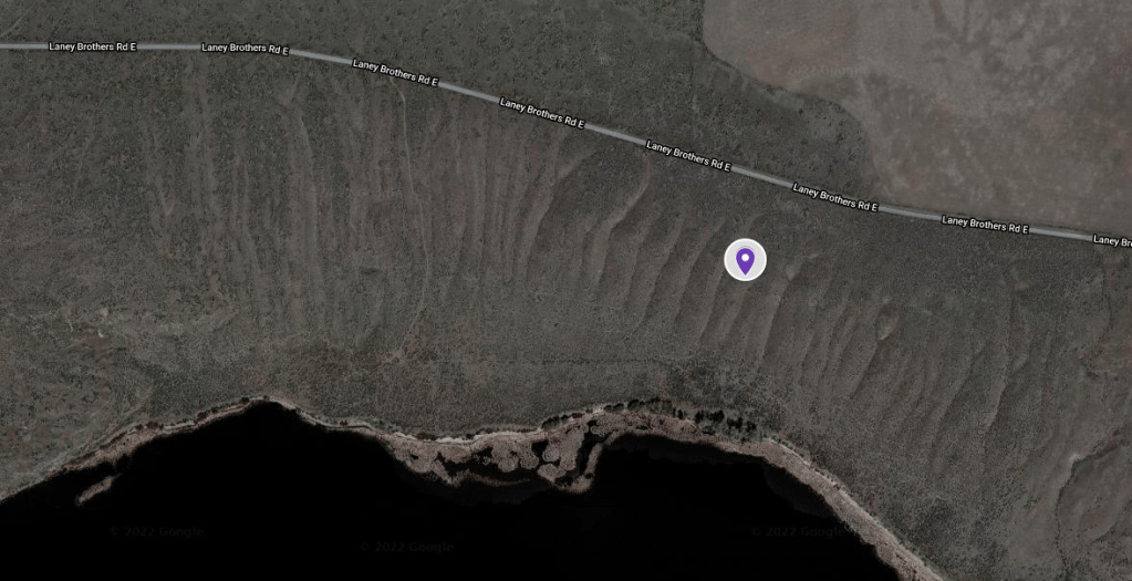
Ripples of this type can be found throughout the Scablands, proving once again that rushing water was the mechanism that formed them.
Erratics
As the waters of the Lake Missoula floods raced across the landscape they scooped up dirt, clay, mud, gravel, topsoil– and boulders. All of this material was deposited downstream in huge piles, and many of the boulders were simply dropped at points along the way. Such boulders are called “erratics” because they originated far from where they were found. Erratics can be found throughout the region. Some erratics may have been carried on or within icebergs that flowed downstream with the rushing waters.
Flood Bars
The waters of the Missoula Floods pushed huge amounts of soil, rock, and other material south and west. Some of this material was pushed as far south as the Willamette Valley in Oregon. Regions where the material was dumped by the floodwaters are known as “flood bars,” and they can be found throughout the region.
Further information
The Missoula Floods have been thoroughly studied and documented, and research on the geological history of this region continues. The Ice Age Floods Institute’s web site at https://iafi.org/ is an excellent resource for further background information. The Institute’s web site includes links to many other sources of information about the ice age floods. Be sure to view the interactive map, as it is annotated with dozens of detailed notes about the Missoula Floods.
Conclusion
The story of the flood in the bible is a ridiculous story. It would have been impossible for the atmosphere to hold any significant percentage of the six mile depth of water that supposedly covered the earth– unless the temperature of the atmosphere were raised to several hundred degrees. I seriously doubt that even the most strident of creationists would expect us to believe that.
The mechanism that creationists would have us believe by which the floodwaters carved out the Grand Canyon is every bit as ridiculous. It doesn’t account for the fact there would have been nothing to distinguish the geology of northern Arizona at the time from that of Dallas. Why didn’t the waters of the flood carve a grand canyon near Dallas? Because the flood story in the bible is a fairy tale, not an historical narrative.
The Grand Canyon is a river erosion geology, not a flood geology. The Channeled Scablands of Washington State are the best example of a true flood geology to be found anywhere in the world– but floods of this dimension undoubtedly happened elsewhere at the end of the last ice age. As the ice age glaciers melted it would have been natural for lakes to form at the southern boundaries of the glaciers. It would certainly have been possible for ice dams that held back the waters of such lakes to collapse, just as did the dam of Lake Missoula. And that could mean that there are other as of yet unrecognized flood geologies that have a history similar to that of the Channeled Scablands just waiting to be discovered.
Copyright (c) 2022 by David S. Moore
All rights reserved
